A multiagency partnership led by the USGS and the Department of Energy seeks to shed light on lithium and other critical mineral resource potential as well as geothermal energy potential in western Nevada, as announced on the website of the U.S. Geological Survey (USGS).
Resource managers and policymakers will soon have a better idea of the potential for critical mineral resources and geothermal energy in western Nevada, thanks to a new multiagency partnership led by the USGS and the Department of Energy’s Geothermal Technologies Office. The effort will include airborne geophysical and lidar data collection, as well as geologic mapping and geochemical analysis of rock and brine samples.
“The data we’ll be collecting are useful for many applications,” said Sarah Ryker, USGS Associate Director for Energy and Minerals. “Not only are we helping identify the potential for mineral and energy resources that underpin our economy, but these data can help identify groundwater resources and even geologic hazards such as faults that could produce earthquakes.”
![]()
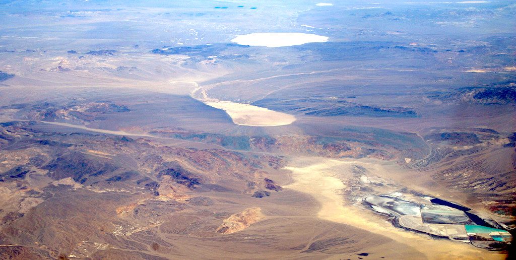
The area of study is the Walker Lane geologic area in western Nevada, which has a high quantity of sediments and clays rocks that may contain significant amounts of critical minerals. The initial focus will be on critical mineral commodities such as lithium and will include rare earth elements, platinum group elements and chromium, as well as iron, nickel and copper.
Lithium is one of the 35 mineral commodities deemed by the Department of the Interior to be critical to the economy and security of the United States. It is used primarily in batteries and electronics, such as electric cars and smart phones. The U.S. is heavily dependent on imports to meet its lithium needs, and currently the only domestic source of lithium is in Nevada.
The Walker Lane area is also highly prospective for geothermal energy resources. Nevada is one of the leading producers of geothermal energy in the U.S., second only to California.
Geothermal is an underutilized energy source within the U.S. In 2008, the USGS assessed geothermal potential in 13 Western states, identifying an estimated 9 gigawatts-electric of geothermal resources with a further 33 gigawatts-electric of undiscovered geothermal resources.
This partnership will allow the USGS to collect airborne magnetic and radiometric as well as lidar data; the Department of Energy’s Office of Energy Efficiency and Renewable Energy will analyze these data using machine learning to identify areas of greatest geothermal resource potential in western Nevada.
The partnership, known as the Geoscience Data Acquisition for Western Nevada project, or GeoDAWN, is managed for the USGS by the USGS Mineral Resources Program’s Earth Mapping Resource Initiative (Earth MRI) and the USGS National Geospatial Program’s 3D Elevation Program (3DEP).
Established as a result of Executive Order 13817, “A Federal Strategy to Ensure Secure and Reliable Supplies of Critical Minerals (2017),” Earth MRI is a partnership among the USGS, state geological surveys, and industry that generates state-of-the-art geologic mapping, geophysical surveys, and lidar data to improve knowledge of the geologic framework in the U.S. and identify areas that may have the potential to contain undiscovered critical mineral resources. Meanwhile, the goal of 3DEP is to complete acquisition of nationwide lidar (IfSAR in AK) by 2023 to provide the first ever national baseline of consistent high-resolution elevation data – both bare earth and 3D point clouds – in a timeframe of less than a decade.
The geophysical survey and geothermal resource analyses will be led by scientists from the USGS Energy Resources Program.
In addition to the Department of Energy’s Office of Energy Efficiency and Renewable Energy, the USDA’s Natural Resources Conservation Service and the Bureau of Land Management have contributed funding to this research.
More information about this project can be found here. More information about USGS mineral resource science, including resource assessments, commodity information, and other studies, can be found on the USGS Mineral Resources Program website or by following us on Twitter.

The USGS Earth Mapping Resources Initiative and USGS 3D Elevation Program (3DEP), Department of Energy Geothermal Technologies Office, Natural Resources Conservation Services, and Bureau of Land Management have partnered to conduct airborne geophysical and 3DEP lidar surveys over parts of Nevada and California to collect information on undiscovered geothermal, critical mineral, and groundwater resources in the western Great Basin and the Walker Lane region.
Geothermal Resources
Recent discoveries have indicated significant potential for geothermal resources in western Nevada, which is already the second-largest producer of geothermal energy in the Nation. This survey will collect information that will highlight which areas to focus on next.
Critical Minerals
The western Great Basin is home to many mineral resources that have been deemed critical by the Department of the Interior, particularly lithium. Lithium is an important commodity for batteries and modern electronics. The study area will focus on lithium- and boron-bearing clays, sediments, and brines.
Groundwater & Agriculture
The airborne geophysical and 3DEP lidar data will reveal more than just energy and mineral resources. The aeromagnetic data will shed light on groundwater potential, while the new lidar and radiometric data will allow for detailed mapping of soils critical for agriculture.
Geohazards
The Walker Lane region of western Nevada and adjacent areas in California contain several areas that could trigger seismic activity. The new topographic and geophysical data should help identify the faults in the region and enable scientists to learn more about the potential for seismic hazards.
*Project Status: In progress as of September, 2020.
Sources:
- https://ngmdb.usgs.gov/emri
- https://www.usgs.gov/special-topic/earthmri
- https://www.usgs.gov/core-science-systems/ngp/3dep
Learn more at www.usgs.gov/earthmri
Source: US Geological Survey